Building on our experience in extended reality for urban planning, we are now extending our skills to the maritime sector. Our ambition remains the same: to develop innovative decision-support solutions for the design of tomorrow’s urban environments.
As part of the DesCartes program, we took a closer look at the management and challenges facing the port of Singapore. One of the world’s largest ports, it faces major logistical and ecological challenges. Thanks to our know-how in immersive and collaborative technologies, coupled with a partner’s hybrid artificial intelligence, we came up with a solution to better understand and anticipate the consequences of a potential incident that could occur in the Port of Singapore’s berthing zone.
AI and extended reality for smart cities
The DesCartes program aims to create an innovative decision-making tool based on hybrid artificial intelligence, specifically designed for (smart cities). How is it hybrid? Enriched by field data and simulations, this technology paves the way for more realistic management of the cities of the future.
In addition to generating usable data, our contribution goes beyond simple data production, as we have provided a solution to data accessibility by developing an Extended Reality (XR) visualization solution.
This 3D visualization technology transforms the way experts apprehend complex information. By making data intuitive and immersive, we facilitate collective understanding and accelerate decision-making processes. Our aim is to enable every expert to quickly grasp technical information, making full use of everyone’s skills in a sophisticated technological environment.
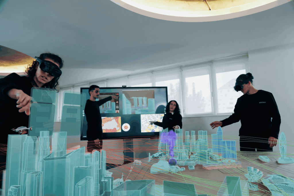
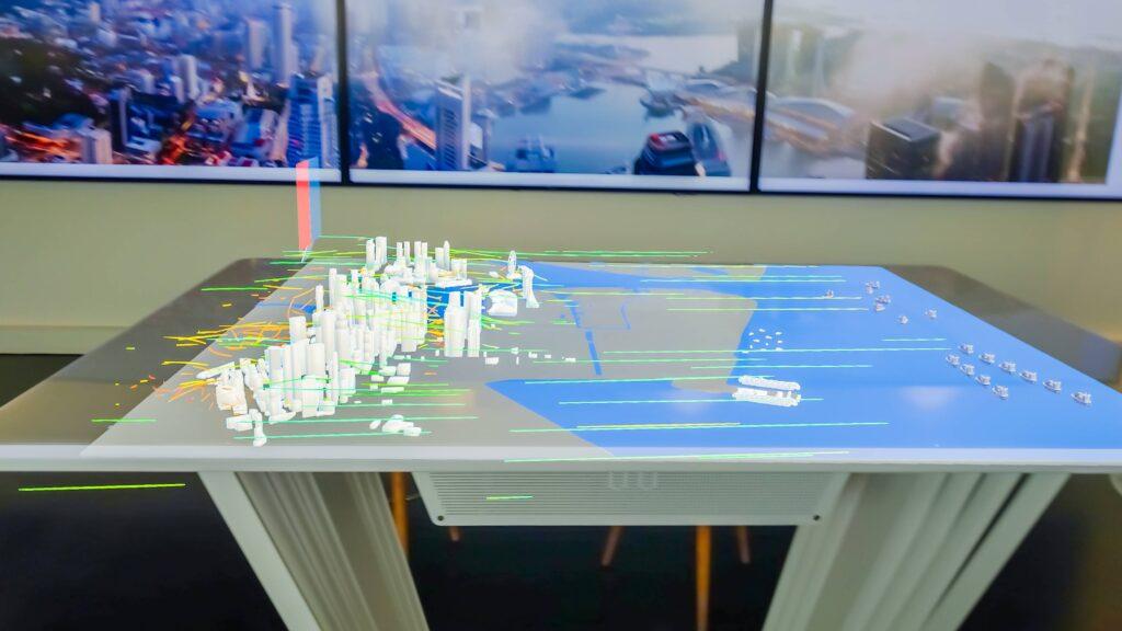
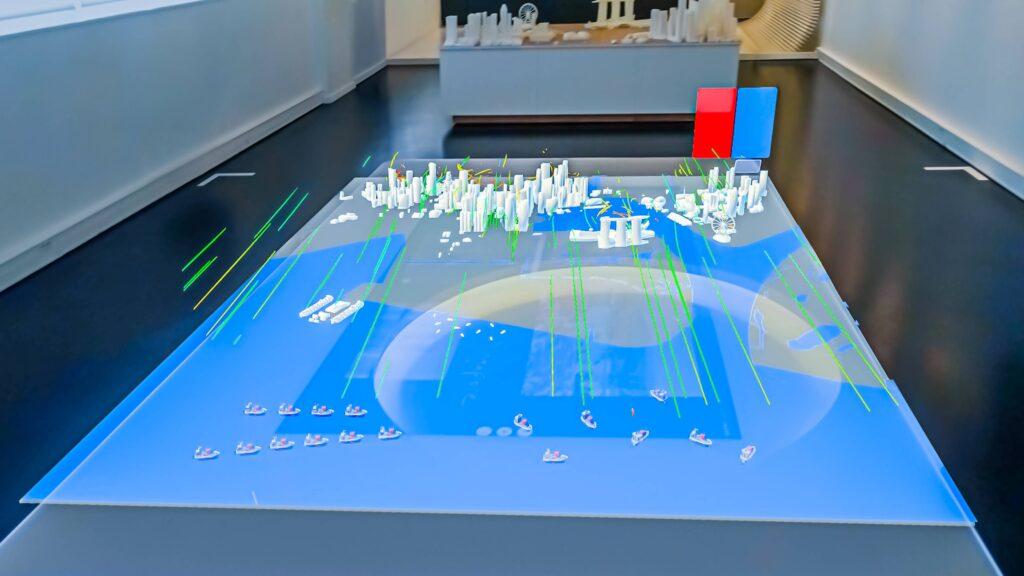
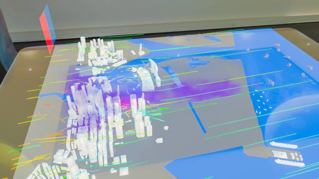
As experts in human-machine interfaces (HMI), Immersion designed and developed augmented reality experiences exploiting AI data around the 3D model of the city of Singapore. This new type of digital twin presented wind, temperature and pollution data, thanks to a few well-positioned sensors and a rigorous physical simulation.
Beyond the 3D visualization, we integrated this experience into our Shariiing ecosystem. Now, each user can accompany his counterpart in his immersive experience and aggregate other types of information, such as maps, procedures or photographs. This approach refines the analysis of the incident and keeps a record of the decision for potential debriefing at a later date.
Following our experiments on drone flight in urban environments, we applied the same approach to the maritime sector, with a particular focus on incident management in the port of Singapore. In the face of growing climatic crises, our tool will no longer be just an asset, but a real safety lever, enabling rapid, appropriate decision-making.
Managing the consequences of incidents: a port in transition
The port of Singapore, one of the busiest in the world, is also a major source of pollution due to ship emissions and surrounding industrial activities. Despite increased air quality monitoring, high levels of fine particles and nitrogen oxides are regularly recorded, highlighting the environmental impact of maritime traffic.
To address these issues, Singapore plans to ban internal combustion engine ships by 2030 and encourage the adoption of cleaner fuels, such as hydrogen and biodiesel. These measures are part of a comprehensive approach to reducing pollutant emissions and improving air quality in the port region.
Despite this favorable context for the reduction of pollution sources, it is difficult to exclude the emergence of incidents causing temporary pollution. Immersion has therefore developed a prototype enabling users to visualize and analyze in real time the propagation of pollution within the port of Singapore, according to the winds circulating over the entire area. This approach, based on dynamic data and immersive tools, aims to offer a precise and exploitable vision of the port environment to facilitate decision-making.
Towards intelligent and responsible infrastructures
Thanks to the DesCartes program, XR technologies for artificial intelligence are becoming essential allies in the management of urban and maritime spaces. By making it easy to visualize advanced simulations and field data, we are helping to build smarter, more resilient and environmentally-friendly infrastructures. This innovation paves the way for a new era of more informed and responsive decision-making.